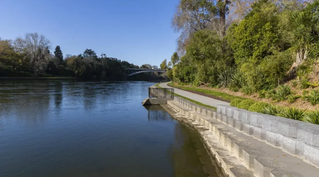
The Waikato River is the waterway that runs through Hamilton, New Zealand, dividing the central city and western suburbs from Hamilton East and the eastern suburbs. It shapes how the city looks, moves and understands itself. Riverside paths connect parks, bridges, the central city and Hamilton Gardens, while the awa holds a much deeper cultural relationship with Waikato-Tainui and other river iwi.
Despite this page’s inherited URL, Hamilton is not where the Waikato and Waipā rivers meet. Their confluence is at Ngāruawāhia, north of Hamilton. This guide corrects that confusion and focuses on the Waikato River in Hamilton: what it means, where to experience it, how the paths connect and what visitors should check before going. Details and source links were reviewed on 8 October 2026.

Waikato River in Hamilton at a glance
| Detail | What to know |
|---|---|
| River through Hamilton | The Waikato River. Hamilton City Council’s River Plan covers about 16 km of the river within the city boundary. |
| Where two rivers meet | The Waikato and Waipā meet at Ngāruawāhia, not in Hamilton city. |
| Main public experience | Shared walking and cycling paths, riverside parks, bridge crossings and links to Hamilton Gardens and the central city. |
| Path layout | Council describes the western path as continuous from Cobham Bridge to Horotiu Bridge. Eastern-bank sections connect through bridges, parks and local streets. |
| Access | Multiple entry points are available. Surface, gradient, closures and facilities vary by section, so check the current Council path information. |
| Important safety point | The river has strong currents and water quality can vary. Do not assume it is safe to swim because conditions look calm. |
For a detailed walking and cycling route, use our dedicated Hamilton River Ride and Walks guide. This article has a different job: it explains the river’s place in Hamilton and helps you choose a meaningful, well-planned river visit without duplicating the route page.
Does Hamilton sit where two rivers meet?
No. Hamilton sits on both banks of the Waikato River. The Waipā River joins the Waikato River at Ngāruawāhia, roughly north of the city. Waikato Regional Council uses an image of that confluence when explaining why water colour and sediment levels change below Ngāruawāhia.
The distinction matters because a memorable title should not become a false geographical fact. Hamilton is still closely connected with the wider Waikato and Waipā catchments, but the river visitors see running through the city is the Waikato. In central Hamilton, it separates Hamilton West and the CBD from Hamilton East before continuing north toward Ngāruawāhia.
If you want to see the actual meeting of the rivers, plan a separate visit to Ngāruawāhia and use current Waikato District information to decide where to stop. Do not treat a roadside glimpse, private land or an unverified map pin as public access. This Hamilton guide stays within the city and points to official path information.
Why the Waikato River is central to Kirikiriroa Hamilton
The Waikato River is not simply scenery beside the city. Te Ara records that Kirikiriroa and other settlements along this part of the river show the area was occupied before the colonial town of Hamilton was established. The river supported movement, food gathering, settlement and relationships between communities across the rohe.
Waikato River Authority explains that the Waikato and Waipā rivers sustained iwi for centuries through food, shelter, healing and the foundations of community life. Its account also places present restoration work within the history of invasion, raupatu, land loss and extensive modification of waterways and wetlands. That context is essential. A visitor guide should not reduce the awa to a pretty backdrop or begin Hamilton’s story only with European settlement.
The Waikato-Tainui relationship with the river is expressed as belonging and responsibility, not simple ownership of an attraction. Te Ture Whaimana o Te Awa o Waikato, the Vision and Strategy for the river, directs restoration and protection of its health and wellbeing. The Waikato River Authority operates through co-governance, with river iwi and Crown representatives. For visitors, the practical lesson is to approach the river with respect: follow access rules, take rubbish away, keep out of restoration areas and use authoritative cultural interpretation.
How the river shaped Hamilton’s two sides
Hamilton developed on both banks. Te Ara describes early colonial Hamilton as two settlements, Hamilton East and Hamilton West, with the river crossed by punt before bridges made everyday movement easier. That physical division still helps visitors understand the city. Hamilton Central and Victoria Street sit mainly on the west, while Memorial Park, Hayes Paddock and established Hamilton East neighbourhoods sit across the river.
Today the river is less a barrier than a connector. Paths pass below or near the road network, bridges create short loops, and riverside green spaces offer ways to move through the city without following the busiest streets. Hamilton City Council’s River Plan treats the river corridor as a citywide system involving access, recreation, the natural environment, arts and culture, tourism and development.

This makes the river useful for orientation. If you know which bank you are on, which bridge is closest and whether your destination sits north or south, the city becomes easier to read. Our Hamilton maps and visitor guide adds city, transport and attraction links for the rest of a trip.
Where to experience the Waikato River in Hamilton
You do not need to complete the entire river path to understand its role. A short, deliberate section can combine scenery, city history and a useful connection between attractions. Choose the starting point that matches the rest of your day.
- Hamilton Central: use a central access point when you want to combine the river with Victoria Street, Waikato Museum or city dining. The river sits below parts of the central street level, so use signed access rather than looking for an informal shortcut.
- Memorial Park: this Hamilton East park has a riverside setting, memorial features and connections toward central bridge crossings. Council describes it as a practical place for a lunchtime walk.
- Hamilton Gardens: the southern river-path connection allows you to pair the awa with the Gardens. Keep enough time for both rather than treating the path as a hurried passage to the ticketed Enclosed Gardens.
- Hayes Paddock and Wellington Street Beach: these riverside areas show a more residential side of Hamilton East. The beach is a scenic place beside the river, but it should not be treated as proof that water conditions are safe.
- Pukete and the northern paths: northern sections connect green spaces, bridges and Te Awa River Ride. Use current maps because a long ride crosses different path environments and local boundaries.
Each option supports a different search intent. Central access is best for a first-time visitor who wants an easy city combination. Memorial Park and Hamilton Gardens suit a slower sightseeing day. Pukete is more useful for people thinking about a longer walk or ride. For specific park information, open the relevant Council page before leaving.
Use the bridges to build a shorter river loop
Hamilton City Council says path users can cross between riverbanks using seven bridges: Cobham, Anzac, Claudelands, Boundary Road, Fairfield, Pukete traffic and Braithwaite foot bridge. That does not mean every pair of bridges creates an identical accessible loop. Approaches, gradients, path surfaces, road crossings and temporary works differ.
A practical loop begins with two questions: how much time do you have, and what do you want to connect? If the goal is central-city orientation, choose nearby central crossings and allow time for stair or ramp access. If the goal is Hamilton Gardens, keep your route south. If you are cycling through the city, follow Te Awa signage and current detours rather than assembling a route from an old blog map.
On shared paths, keep left where indicated, control speed and signal before passing. Council specifically asks people riding bikes to travel at safe speeds and use a bell or voice to alert pedestrians. A river path can feel recreational, but it is also a commuting route and an access space used by people with different speeds and mobility needs.
Plan the actual river path
Use Hamilton City Council’s current path description for bridge connections, facilities and shared-path advice.
Open the official river-path page ↗Walking, cycling and Te Awa River Ride
The city river path forms part of a larger walking and cycling network. Council describes the Hamilton River Path section of Te Awa River Ride as running along the Waikato River through the length of the city, linking green spaces, the CBD and Hamilton Gardens. Facilities on that route can include directional lanes, repair stations, toilets, drinking fountains, lighting, signs and cafés, but availability is not identical at every point.
Walking allows more time for river views, interpretation and short diversions into parks. Cycling makes a longer section practical, but it also increases the need to manage speed around walkers, children, dogs and blind corners. Treat any published distance or time as a planning estimate, not a promise. Weather, stops, gradients, closures and your chosen bridge crossings can change the outing.

For a longer regional ride, use the official Te Awa River Ride website for current maps, alerts and section planning. The Hamilton section should not be confused with the Waikato River Trails network farther south. Similar names can send visitors to the wrong route if they rely only on a search snippet.
Water quality, swimming and river safety
The Waikato River can look slow from the bank while carrying a powerful current. Water levels, flow, debris and water quality can change. Waikato Regional Council says water quality varies along the river and that the city reaches and downstream have not always met safe-swimming levels. That evidence is a reason to check current information, not a permanent verdict for every location and day.
- Do not enter the water solely because other people are swimming or the surface looks calm.
- Check current water-quality and public-health advice for the exact site.
- Obey warning signs, barriers and temporary closures.
- Supervise children closely near banks, ramps and unfenced edges.
- Keep clear of rowing shells, boats, launching areas and working river users.
- After heavy rain, expect conditions and water clarity to change.
Wellington Street Beach and other access points are places beside a live river, not managed swimming pools. Our Wellington Street Beach guide explains that location without presenting it as universally safe for swimming. If your priority is a supervised aquatic activity, use current Hamilton pool information instead.
River health and restoration are part of the story
The river supports drinking-water supply, recreation, ecological systems, industry, agriculture and communities along a large catchment. These uses also create pressure. Waikato Regional Council monitors river water quality, while the Waikato River Authority supports restoration under Te Ture Whaimana.
Visitors may notice restoration planting, erosion control, pest management or temporary access restrictions. These are not visual inconveniences to bypass. They are part of the work required to protect banks, habitats and water. Stay on formed paths where directed, avoid trampling new planting and clean mud from footwear or bike tyres before moving between waterways.
The river’s appearance also changes naturally. Waikato Regional Council explains that sediment from the Waipā affects colour below the confluence at Ngāruawāhia. Clear-looking water is not automatically clean, and brown-looking water does not have one simple cause. Current monitoring and site advice are more useful than judging quality by a photograph.
Choose a river visit that fits your day
| Your priority | A sensible plan |
|---|---|
| First visit to Hamilton | Start near the central city, walk a short river section, cross one bridge and connect with Waikato Museum or Victoria Street. |
| Gardens plus river | Visit Hamilton Gardens, then add a riverside walk only if time, daylight and weather suit your group. |
| Easy family outing | Choose one park and a short out-and-back path. Check toilets, playgrounds, barriers and current access before promising a loop. |
| Longer cycle | Use the current Te Awa map, carry water and repair basics, and check alerts for the full section you intend to ride. |
| Culture and history | Combine the river with Waikato Museum and authoritative Waikato-Tainui or Waikato River Authority interpretation. |
Avoid overloading the day. Hamilton Gardens, the river, the museum and the central city can fit together geographically, but each deserves time. A better plan usually includes one main attraction, one river section and one meal or rest stop. That leaves room for weather, parking and the possibility that you will want to stay longer.
Accessibility, weather and practical planning
Hamilton City Council describes many river-path areas as wheelchair and pushchair friendly, with multiple entry points, parking and toilets. That broad description does not guarantee every approach, bridge or detour will suit every user. Gradients down from street level, temporary works, wet leaves and path transitions can affect a specific trip.
- Open the official path page and map close to your visit.
- Check the Hamilton weather guide, then use a live forecast on the day.
- Allow extra time if your route depends on lifts, ramps, an accessible toilet or a particular parking space.
- After rain, expect slippery leaves, puddles and softer unsealed edges.
- Carry sun protection and water because shade changes between sections.
- Plan a turnaround point rather than assuming everyone can complete a long loop.
If a mobility requirement is essential, contact Hamilton City Council about the exact section. For buses into the central city or toward major attractions, use our Hamilton bus guide and confirm the live BUSIT journey plan before travelling.
How this guide strengthens a Hamilton visit
The Waikato River connects several subjects that visitors otherwise search for separately: Hamilton walks, city maps, Hamilton Gardens, local history, parks, cycling and the meaning of Kirikiriroa. That makes this page a supporting part of the site’s Hamilton NZ topic cluster, while the specialist pages keep their own clear jobs.
- Use Hamilton River Ride and Walks for the dedicated path guide.
- Use Hamilton Gardens for tickets, hours and visitor planning.
- Use Waikato Museum for a cultural and historical stop overlooking the river.
- Use featured Hamilton attractions to build a wider city day.
- Use things to do in Hamilton when you need options by activity type.
These links are deliberately selective. Repeating every nearby listing would blur the purpose of this article and compete with dynamic hubs. The river page should answer river questions, then send readers to the most relevant next guide.
Frequently asked questions about the Waikato River in Hamilton
What river runs through Hamilton, New Zealand?
The Waikato River runs through Hamilton. It passes between Hamilton Central and Hamilton East before continuing north toward Ngāruawāhia and, eventually, Port Waikato.
Do the Waikato and Waipā rivers meet in Hamilton?
No. The Waikato and Waipā rivers meet at Ngāruawāhia, north of Hamilton. Hamilton itself is built on both banks of the Waikato River.
Can you walk beside the Waikato River in Hamilton?
Yes. Shared paths run beside the river through Hamilton. Council describes the western route as continuous from Cobham Bridge to Horotiu Bridge, while eastern sections connect through bridges and parks.
Is the Hamilton river path suitable for wheelchairs and pushchairs?
Council lists the river walks as wheelchair and pushchair friendly, but access varies by entry point and section. Check the exact route, gradients, surfaces and any temporary closures before visiting.
Can you cycle along the Waikato River in Hamilton?
Yes. The Hamilton river path forms part of Te Awa River Ride and is shared by people walking and cycling. Ride at a safe speed, keep to marked directions and signal before passing.
Is it safe to swim in the Waikato River at Hamilton?
Do not assume a Hamilton river site is safe for swimming. Currents are strong and water quality varies. Check current monitoring, health advice and signs for the exact location before considering water entry.
Which Hamilton attractions connect with the river path?
The path links or sits close to Hamilton Gardens, Memorial Park, central Hamilton and Waikato Museum, with further parks and neighbourhood access along the corridor.
Why is the Waikato River culturally important?
The awa has sustained iwi through food, travel, shelter, healing and community life for generations. Its health and wellbeing are central to Te Ture Whaimana and present co-governance and restoration work.
Official sources and further reading
- Hamilton City River Rides and Walks for current city path, bridge, facility and shared-use information.
- Hamilton River Path section of Te Awa for the official city connection description.
- Te Awa River Ride for current regional route maps and trail alerts.
- Waikato River Authority purpose for co-governance and Te Ture Whaimana.
- Waikato River Authority history for river settlements and restoration milestones.
- Waikato Regional Council river information for catchment and monitoring resources.
- Waikato River water-quality explanation for monitoring context and the Waikato-Waipā confluence.
- Te Ara’s Hamilton history for Kirikiriroa, riverbank settlement and the development of Hamilton East and West.
The Waikato River is the clearest physical thread through Hamilton, but it should be understood as more than a view. Walk a manageable section, read the place names and interpretation, notice how the bridges connect the city and leave the river corridor as you found it. That is a better way to experience the heartbeat of Hamilton than any invented story.